
Keylakunu is a mangrove & wetland in Haa Dhaalu Atoll (Thiladhunmathi Dhekunuburi), Maldives. It was declared a protected area in 2018 under the Environment Protection and Preservation Act. The protected zone covers about 235.3 hectares (2.35 km²). Protection category: Category 6: Habitat/Species Management Area, Category 7: Protected Area with Sustainable Use. The nearest inhabited island is Kumundhoo, about 5.9 km away.
Also mentioning Keylakunu
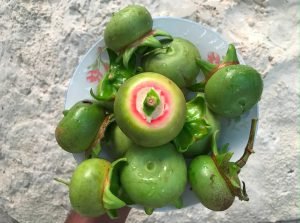 Sonneratia caseolaris – Kuhlhavah
Nearest islands
More dive sites & protected areas nearby
Photos
No visitor photos of Keylakunu yet. Be the first!
Share your photo of Keylakunu
Protected area record: Environmental Protection Agency, Protected Areas of the Maldives (2023–2024 lists). The circle on the map shows the size of the protected zone, not its exact boundary.